Southern Maryland Important Bird Areas Inform Land Use Planning
What are Important Bird Areas?
Audubon’s Important Bird Areas (IBAs) are sites that support significant populations of birds considered vulnerable to habitat loss and degradation. Vulnerable birds include not just rare, threatened and endangered species, but also a variety of species still fairly common and widespread. These can be vulnerable for two principal reasons: 1) they may be habitat-specialists, requiring a particular type of habitat, such as forest or marsh, and 2) they may spend part of the year in dense aggregations, such as nesting colonies or migrating/winter flocks. IBAs are identified using scientifically rigorous criteria based on these categories of birds - these IBA criteria and other information are available here.
Audubon has identified over 2,600 IBAs in 47 states in the U.S. as part of a global conservation initiative coordinated by Birdlife International. As of 2015, 43 Important Bird Areas have been identified in Maryland and their boundaries mapped using a Geographic Information System (GIS). The goal of the IBA program is to maintain a network of sites that will provide for the long-term conservation of these birds and thus prevent the need for their future listing as rare, threatened or endangered. IBAs can assist land use planning in several ways, as outlined below, including prioritizing zoning locations, targeting lands for protection, educating the public, and securing state funding.
Threats to Birds
The Maryland State Wildlife Action Plan, updated by Maryland Department of Natural Resources in 2015, describes one of the greatest threats to birds and other wildlife as the loss and fragmentation of habitat due to development. Between 1973 and 2010 developed land in Maryland increased by 154% while the population grew by only 39%. Over one million acres of farmland and forest have been lost in the state since 1973. More than half of the recent increase in development is attributable to low density residential use. As natural habitat is lost, remaining habitat patches are not only eroded but also fragmented, greatly reducing patch size. These combined impacts have caused population declines in many habitat-specialist birds because these species tend to require larger areas of contiguous habitat than do generalists. Forest Interior Dwelling Species (FIDS) are one such specialist assemblage – these birds need large areas of intact forest to breed successfully. The larger the area and the higher the ecological quality of a forest, the higher the number of FIDS species it will support.
Important Bird Areas in Southern Maryland
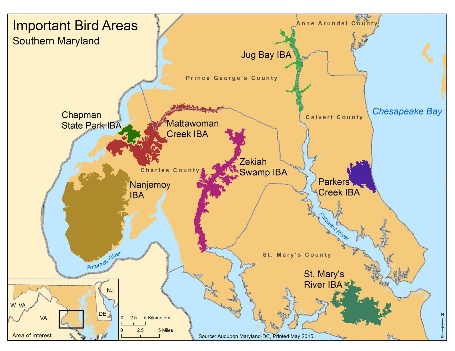
The seven IBAs of Southern Maryland total an area of 110,236 acres, only 39% of which is permanently protected. Southern Maryland hosts some of the state’s best unmanaged hardwood forests, one of the most critical habitats for bird conservation in the state. Meanwhile, this diversity-rich region struggles with some of Maryland’s fastest land consumption rates. Along with Western Maryland and the Lower Eastern Shore, Southern Maryland remains one of the richest biological regions in the state. A detailed site description of each IBA in Southern Maryland accompanies this report, and a spatial data layer of IBA boundaries is being provided to the planning departments of Prince George’s, Anne Arundel, Calvert, Charles, and St. Mary’s counties and to the Maryland Department of Planning for use in mapping. Click on the links below for information about individual IBAs in Southern Maryland:
IBAs, Green Infrastructure, and Land Use Planning
One of the most effective ways to ensure the long-term conservation of birds and their habitats is through land use planning. Because bird diversity correlates well with biodiversity and because birds are among the measures used by the state to set conservation priorities, IBAs can bolster the argument for protecting networks of lands already identified as high priorities for conservation.
Driven by real bird data, IBA identification has a close natural fit with Maryland’s most ecologically-valuable undeveloped lands. In mapping the IBAs, we have aligned site boundaries with contiguous forest (green infrastructure) hubs whenever appropriate (see links below). Not all hubs qualified as IBAs, but for those that did, the hub boundaries generally delineated the extent of suitable habitat for the target bird species present. Three types of adjustments were made to hub boundaries in order to create IBA borders: 1) Areas of coastal marsh habitat outside but adjacent to a hub were included, 2) Areas of habitat known to be severely degraded or lost since completion of the forest hub assessment were excluded, 3) Gaps in the green infrastructure fully or mostly enclosed by a forest hub were included in IBAs.
Specific ways in which IBAs can assist land use planning include the following:
-
Prioritization: IBA identification and the ornithological data underlying it can be used to prioritize protective zoning of areas within the green infrastructure network already identified by the state of Maryland for protection. The data used for documenting IBAs includes analyses of sensitive species, including species assemblages such as Forest-Interior Dwelling Species (FIDS), which are listed in the IBA criteria for site selection. Guidelines produced by Maryland Department of Planning on developing the Sensitive Areas Element of county comprehensive plans, state that counties must identify the location of forestlands intended for resource protection or conservation. IBA documentation can provide the technical information required for this element.
-
Conservation programs: IBA identification can assist the process of obtaining funding for land protection (see links below). The five most common types in Maryland include: Rural Legacy, Maryland Environmental Trust and Maryland Agricultural Land Preservation Foundation easements, Program Open Space acquisitions, and the federal Agricultural Conservation Easement Program (formerly WRP). Many other conservation programs exist in Maryland. Local land trusts and county Soil Conservation Districts can assist counties and landowners with options. All of the Southern Maryland IBAs possess Targeted Ecological Areas that the state prioritizes for acquisition. In addition, all or parts of the Parkers Creek, Zekiah Swamp and Jug Bay IBAs boast lands eligible for Rural Legacy easements.
-
Education: Birds are very popular with the public. In 2015, more than a million Marylanders identified themselves as “birdwatchers.” Thus, the alignment of IBA boundaries with green infrastructure can serve to highlight the ecological value and raise the profile of green infrastructure among the public, bringing further justification and an active constituency for more protection of this land network.
Important Bird Areas and the economy
Birds can contribute greatly to the local economy through nature-based tourism, which is the fastest growing component of the tourism industry. More than $600 million is spent annually in Maryland on wildlife-related activities. Birding trails, containing maps and site guides, are becoming increasingly popular around the country and generally include IBA status of sites as an additional attraction. Large contiguous protected areas near urban centers also lure millions of additional dollars annually from hikers, bikers, paddlers and other outdoor enthusiasts.
Important Bird Areas and BioNet
Since 1980, DNR has been analyzing and distributing data on the habitats of the state’s rarest plants and animals as well as high quality and rare natural communities. To facilitate the dissemination of information on Natural Heritage Areas, Critical Areas, and Sensitive Species Project Review Areas DNR created a digital mapping tool called BioNet. The GIS tool can help planners and conservation organizations identify high priority conservation areas and direct growth away from them. BioNet has a dual focus on both the most irreplaceable species and habitats and the areas that concentrate the largest number of rare species. The tiered priorities range from Tier I (critically significant for biodiversity) to Tier V (significant). Audubon IBAs that support significant FIDS habitat are considered Tier III or highly significant for biodiversity. You can access BioNet layers here.
Goal
By providing spatial data on IBAs to planning departments and publicizing the ecological and economic value of these areas, Audubon aims to help implement conservation actions that save these remaining special places. It should be stressed, however, that birds represent just one layer within the larger picture of biodiversity conservation. Although there is general concordance between IBAs and non-avian biodiversity hotspots, there are many Ecologically Significant Areas (ESAs) identified by Maryland’s Natural Heritage Program which lie outside the IBA network, and these too need incorporating into land use planning. Natural Heritage Program staff can be contacted directly for information about ESAs and how to conserve them.
Important links
Maryland Department of Planning data: http://planning.maryland.gov/OurWork/growthTrends.shtml
Maryland Department of Natural Resources Targeted Ecological Areas: http://geodata.md.gov/sggatlas/index.html?sggWebmap=5bc1ae879a4d462995f63c5679c93807&sggTheme=greenPrint&extentBBox=-8701898.712907465,4637294.801374331,-8404405.798821704,4831139.105105445&extentSR=102100
Land conservation options:
http://dnr.maryland.gov/land/Pages/LandConservation/default.aspx
http://mda.maryland.gov/malpf/pages/default.aspx
Land trusts of Maryland:
http://findalandtrust.org/states/maryland24/land_trusts
Data layers: (MD Merlin, Bionet, and Water Resources Registry)
http://dnrweb.dnr.state.md.us/gis/spatialdata/FocalAreas/BioNet/BioNet.htm
http://dnrweb.dnr.state.md.us/gis/data/
http://watershedresourcesregistry.com/
http://staging.mesgis.com/wrr/index.html
For more information on Important Bird Areas and how IBAs can assist land use planning efforts in Southern Maryland please contact Dr. David Curson, Director of Bird Conservation at Audubon Maryland-DC by telephone: 410 558 2473, or by e-mail at: dcurson@audubon.org.
How you can help, right now
Donate to Audubon
Help secure the future for birds at risk from climate change, habitat loss and other threats. Your support will power our science, education, advocacy and on-the-ground conservation efforts.

Become a Monthly Donor
Donating monthly is flexible, easy and convenient and makes you a champion birds can count on, no matter the season

Birds Need You!
Get involved in helping to preserve our birds and their habitats today. There is something for everyone!